States and counties in the United States are using technology for early-warning alerting of wildland fires, pinpointing the location at the moment of inception or shortly thereafter so fire departments and fire agencies can respond quickly and deal with a small wildland fire before it gets a chance to become a large fire.
Joe Wanko, general manager of EnviroVision Systems Inc., says his company makes and supports the ForestWatch® Wildfire Detection and Monitoring System, which uses advanced video analytics and precision cameras to detect and locate the first indications of smoke from a wildland fire.
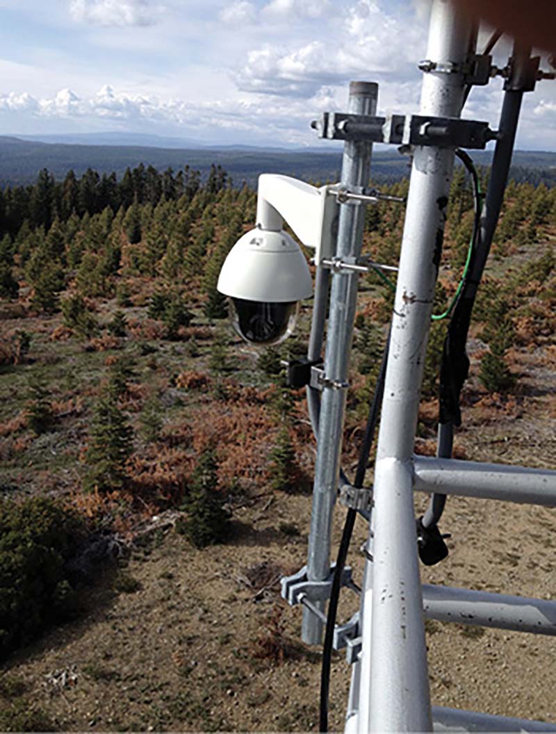
1 A ForestWatch Wildfire Detection and Monitoring System camera is shown installed on a former fire lookout tower in Oregon. (Photos 1-3 courtesy of EnviroVision Systems Inc.)
“The ForestWatch automated fire detection and decision support system combines mounted, programmable cameras; communication links; computer hardware; and some of the most advanced image processing software in the world,” Wanko says. “Together, these elements create a powerful, and highly intelligent, early warning system.”
Wanko says the functionality of ForestWatch is divided into three layers—an imaging layer consisting of a camera, power supply, and image sampling engine; a communication layer made up of a communications link; and a machine vision layer that consists of an operations center, multiview display, computers, ForestWatch software, and servers.
A ForestWatch pan/tilt/zoom camera is typically mounted in an optimal high position, such as on an existing communications or lookout tower or even on a specially constructed stayed mast, Wanko notes. “Most importantly, the camera should have an unobstructed 360-degree view of its surroundings,” he says. “The camera works 24 hours a day and is programmed to continually rotate and scan preset subsections of the landscape at an optimal distance of up to 10 miles (16 kilometers) with one scan taking between two and six minutes.”
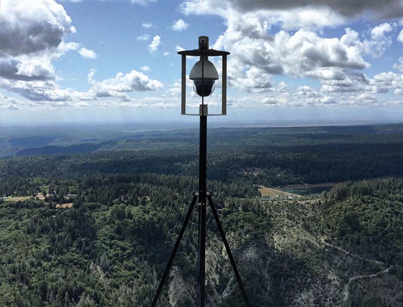
2 This ForestWatch camera is mounted on a stayed mast on a structure’s rooftop.
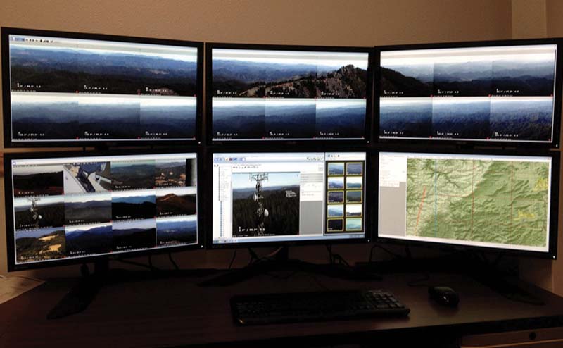
3 A ForestWatch detection workstation.
While working with live video, the ForestWatch camera also captures a sequence of still images at each section, which are then optimized (stabilized and compressed) by the on-site image sampling engine, a small, computerized image processing unit, before being forwarded to the operations center for analysis by the system software. The communication link between the camera and the operations center can take the form of a microwave link, a wireless internet, a fiber optic cable, or a satellite connection. Wanko says that given the remote location of so many cameras, microwave links and satellite communication are most commonly used when setting up a ForestWatch system.
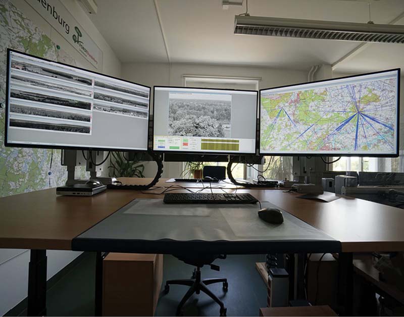
The operations center is where images from the camera are automatically analyzed by the ForestWatch software and viewed by a human operator on a computer. Each operator can monitor the feeds of up to eight cameras at the same time with a multiview display allowing for panoramic views for efficient monitoring of much more terrain. In addition, the operator works with three other screens, including a detection screen where the ForestWatch software automatically compares the captured images using a mathematical algorithm to detect for scene changes that may be smoke. When a potential problem is detected, the operator is alerted, and the “offending” images are placed on a Watch List on the side of the screen for further examination.
Once alerted to a potential problem, the operator uses a view screen to look at live uncompressed video footage (optimized at eight frames a second for transmission over the communication link) and manual camera controls (pan, tilt, zoom) to examine the problem area more closely and potentially confirm the alarm. When the operator mouse-clicks on smoke on the detection screen, that point is immediately highlighted on a GIS screen’s terrain map. Along with exact geographical coordinates, this screen will highlight other important spatial information like property borders and wind direction.
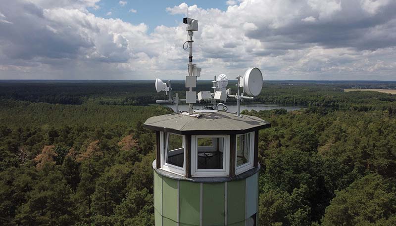
4 An IQ FireWatch camera crowns this former fire lookout tower. (Photos 4-6 courtesy of IQ Technologies for Earth and Space GmbH.)
5 An IQ FireWatch operating workplace.
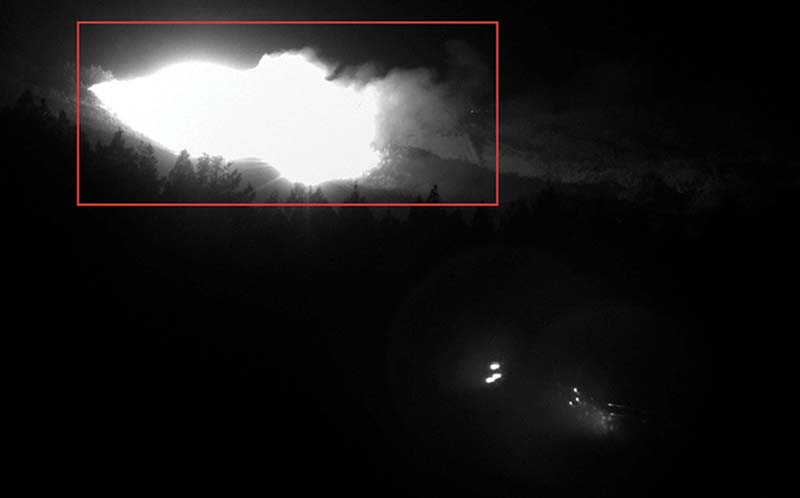
6 A detection image from an IQ FireWatch camera of the Glass Fire in Northern California in September 2020.
Wanko says the operations center also contains a dispatch computer, which, at the click of a button, can immediately alert senior decision makers and emergency response personnel to a developing situation via the internet or mobile phone. He says progress of a fire is distributed to all key stakeholders immediately in this way, supporting better decision making and resource deployment. “In addition, all camera footage is marked with date and time stamps, tower information, and camera settings and archived in image servers at the operations center,” Wanko says, “for record keeping and post-event analysis.”
Wanko says that Douglas Fire Protection Association in Douglas County, Oregon, currently has 36 ForestWatch cameras installed in its forests and that EnviroVision Systems also has cameras set up for the Oregon Department of Forestry in the Northeast, Central, and Southwestern areas of the state, for a total of 100 ForestWatch cameras in Oregon.
Kurt Winter, PhD, chief executive officer of IQ Technologies for Earth and Space GmbH, says IQ FireWatch, his company’s terrestrial visual early detection system, detects smoke and smoke-like events during day and night under all weather conditions and under optimal conditions at distances of 25 miles or more.
Winter notes that the IQ FireWatch system is composed of a sensor unit, a control unit, and detection software that seamlessly interact with the hardware. The system’s sensor unit is installed directly in endangered areas on existing infrastructure, such as telecommunication towers or former fire watch towers at least 16½ feet (five meters) above the treetops.
The sensor unit consists of a monochrome sensor for daytime images, a near-infrared sensor for nighttime images, and an RGB sensor for additional spectral information. Winter points out that because of the unique interaction of the sensors, the covered spectral range is significantly broader compared to the human eye as well as conventional cameras and has a higher probability of detection in all regions, vegetation, and operating conditions.
As soon as the IQ FireWatch software detects smoke that is not located within exclusion areas, a message is sent from the sensor to the control center or to the workstation responsible for it. The operator receiving the message verifies it and either forwards the fire to the fire control center or discards the message. The fire department receives a precise alarm message with the exact time, position, image, and map of the smoke while additional up-to-date information can be found in an app for mobile devices. The precise calibration and measurement of the cameras make it possible to determine and forward the exact geocoordinates for each detection message on the camera image.
Winter says three IQ FireWatch sensors are installed in the City of Redding (CA) as an essential part of its Wildfire Mitigation Plan, and a system also is installed in Atlas Peak (CA), Napa County. He notes that in Fall of 2020, two of the IQ FireWatch sensors (in demo mode at the time) independently detected the large Glass Fire in Northern California under difficult conditions within minutes of its start. The fire broke out in the middle of the night in a hilly area not directly visible to the sensors.
“Due to the night detection by means of the NIR sensor, which makes use of the property of reflection of light in smoke clouds in the near-infrared range, the Glass Fire was detected very quickly,” he says. “For the human eye, this fire would not have been visible at this stage. The unique interaction of our sensors used with the software ensures a monitoring radius of 13 miles even under difficult conditions; and in good conditions, which often dominate during the most fire-prone summer season, distances of 25 miles and more are not an insolvable problem.”
ALAN M. PETRILLO is a Tucson, Arizona-based journalist, the author of three novels and five nonfiction books, and a member of the Fire Apparatus & Emergency Equipment Editorial Advisory Board. He served 22 years with the Verdoy (NY) Fire Department, including in the position of chief.

